Maps vs. the ground truth in Phoenix, AZ: ready for autonomous driving? See Report
Nexar’s CityStream analyzes real world data for making better decisions

We See Changes So You Can Act. Fresh images and AI detections from a vision network, for a digital twin of roads and cities.

We See Changes So You Can Act

Fresh images and AI detections from a crowd-sourced vision network, for a digital twin of roads and cities.

Nexar’s CityStream analyzes real world data for making better decisions

CityStream®

CityStream uses trillions of images received from the Nexar dash cam network to produce insights that help you make better decisions. Using artificial intelligence, CityStream analyzes frames and gets you actionable data from the physical world so you can make better decisions.

Introducing crowd‑sourced vision

Dash cams
collect images

Users contribute anonymous images and videos of the world

Fresh images
and detections

Unique collection of imagery and AI to make sense of the data

In context
and localized

Images and detections are accurately located, for context and time-based change detection

CityStream®Play

Fresh Data, Better Decisions

Nexar’s network of connected vehicles provides trillions of fresh, ground-level images and creates the largest road vision data inventory. You can see road signs and construction zones in the correct location as well as see any changes to them, in context.
Nexar detected changes

Using Vision for Safety

Changes in signs, road furniture and traffic happen on a daily basis, affecting the safety of drivers and pedestrians. Nexar enables cities and DoTs to improve safety on the road through a visual record of the road as well as AI detections.
Nexar detected changes
Nexar’s CityStream uses trillions of images received from the Nexar dash cam network

Our Coverage

B

Total Driven
Miles

M

Total Miles
per Month

T

Images in
Neural Library

Work Zones

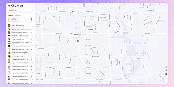
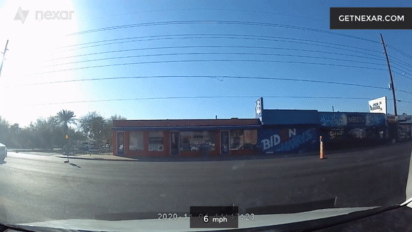
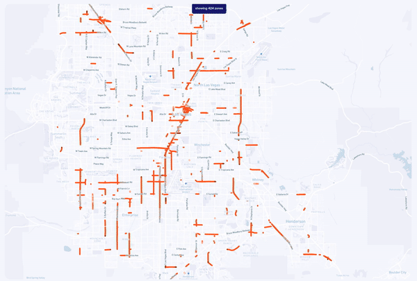
With CityStream Road Work Zones you can detect, monitor, and map all road work zones in your area of interest. Nexar automatically detects barricade elements in work zones using Artificial Intelligence. Recent images of these barricade elements are then aggregated, localized and mapped into CityStream Road Work Zones so you can remotely manage them and be WZDx ready.

Nexar’s CityStream  automatically detects barricade elements in work zones using AI

Road Asset Inventory

Nexar detects road inventory - traffic signs and other furniture - localizes and places it on a map, giving you a fresh understanding of inventory instead of a once-a-year drive through. You can access the underlying images to see for yourself. Nexar also “sees” change, notifying you when road inventory changed, so you can see whether there is a safety or maintenance issue you need to tend to and act upon, Identify damaged, missing, or other changes in road signs, remotely.

Nexar’s CityStream provides road inventory service for monitoring traffic signs & signals

Virtual Camera

With Virtual Camera you can explore the physical world with the most up‑to‑date ground‑level imagery in existence. Frames from the Nexar network are made accessible on a map so that you can easily pick any location of interest and place a “virtual camera” around it so you can monitor it remotely.

Nexar’s CityStream provides virtual camera service for exploring most up‑to‑date ground‑level imagery

Parking

CityStream leverages vision-based AI to localize, aggregate and contextualize free curb spaces in cities. You can see how curb use and parking spaces evolve as the day unfolds.

Nexar parking captures parking spots

Add Cameras to Your Municipal Fleet

Increase your fleet's safety and collect quality data with Nexar’s dash cams. Access Nexar footage to both protect your drivers and the people in your city, with better coverage.

Nexar streets enables access to fresh imagery by location and address

Accessible on many platforms

Nexar data can be accessed on the CityStream platform or through an API on tools such as ESRI.