
Bringing Taxis Into the Connected Vehicle Era
Nexar is now collaborating with Flywheel, the nation’s leading e-hail platform for taxis, to bring our connected vehicle technology to thousands of taxis across the United States and beyond.

Nexar is now collaborating with Flywheel, the nation’s leading e-hail platform for taxis, to bring our connected vehicle technology to thousands of taxis across the United States and beyond.

This glossary offers over 100 definitions for common terms in the context of real-time mapping. As a guiding principle, we opted to include generally accepted definitions as well as to explain (whenever appropriate) how each entry applies to the key concepts in real-time mapping. Part one can be found here
Six years ago, my partner, Bruno Fernandez-Ruiz, and I, started the journey of Nexar. Today Nexar is announcing a round that brings its total funding to $153 million. This is an opportunity to explain what we’ve been working on since our last round last year and where we plan

We at Nexar have been watching closely the talk of a massive infrastructure reform package coming out of Washington DC. To say it doesn’t look like we’re getting that deal anytime soon would be…an understatement. There’s no doubt that America’s roads, bridges, airports, telecom networks,

Discover why I’m thrilled to lead Enterprise Growth at Nexar, where we're transforming the automotive and mobility industries with AI-powered dash cams and a vast network of real-time video data.

This glossary offers over 100 definitions for common terms in the context of real-time mapping. As a guiding principle, we opted to include generally accepted definitions as well as to explain (whenever appropriate) how each entry applies to the key concepts in real-time mapping. A Advanced Driver Assistance Systems (ADAS)
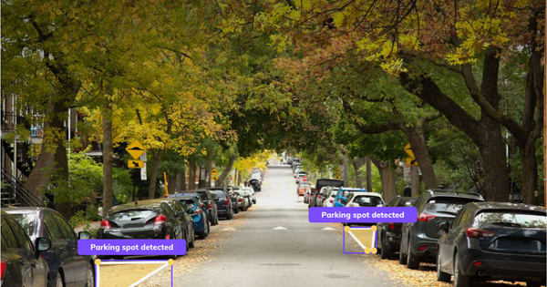
What it takes to create a crowd-sourced identification of free, on-street, parking During February 2021 we used images collected from dash cams and AI to map on-street parking spots in Milan. We wanted to understand the city’s curb-side and prove the value of real-time, free-parking-spot detections for drivers and

Toyota’s recent announcement to halt the deployment of 802.11p (DSRC or ITS-G5) vehicle-to-vehicle technology in new cars may come as a surprise to some.
Software is eating the roads. This might seem like a grand statement, but in the 7 years since I co-founded Nexar with Bruno Fernandez-Ruiz, it has also become glaringly apparent. In practice, this means that vehicles are becoming increasingly software-centric - prioritizing the consumer demand and experience. The implications are
I’m very excited to share that Nexar is acquiring Veniam, a Portugal-based company who is a leading provider of intelligent networking for the internet of moving things. This is a big deal for us, being our first acquisition, and I wanted to share the importance of this step for

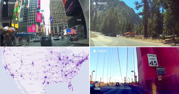
Over 50-thousand commuter and professional drivers across the US utilize Nexar’s intelligent, connected dash cam system, capturing over 60-million miles per month. Nexar extracts and refines the dash cam footage using advanced AI and combines it with mobility data to deliver meaningful, real-time insights with supporting ground-level imagery. In

The Nexar Mobility Network has the potential to become a key component of the world’s present and future, making transport and mobility both safer and more efficient. This network will become an essential part of our lives and will provide the same level of welfare we see in other